Project: Cossans Solar and BESS
Introduction
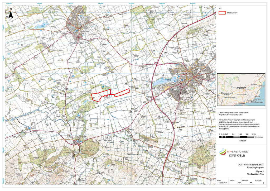
Located in Angus, Cossans Solar and BESS Development is expected to generate up to 60 GWh of renewable energy per year.
Status
Planning submitted
Size
50MW
About the project
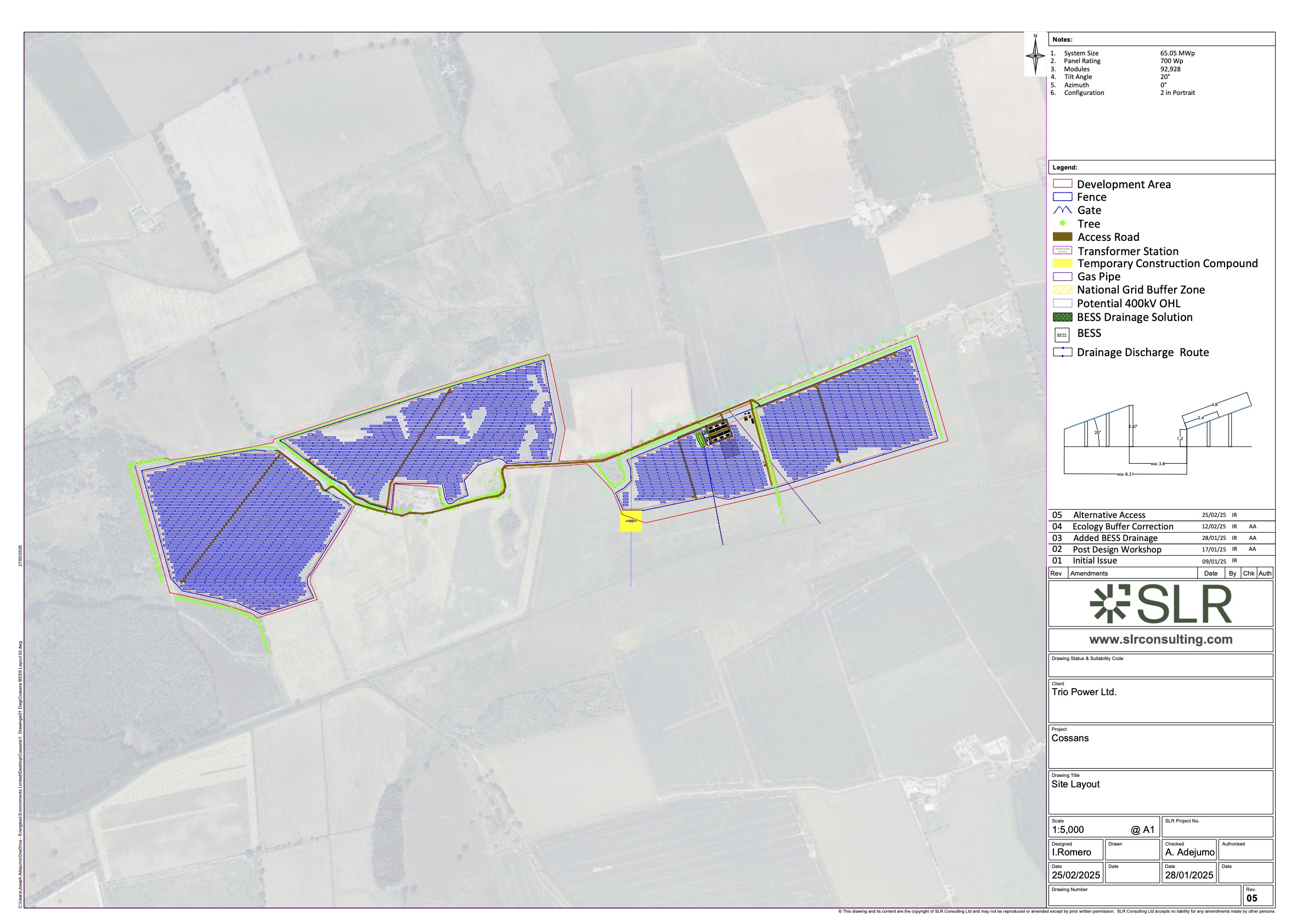
- Cossans Solar & BESS will comprise approximately 100,000 individual solar panels which will sit approximately 2.5ft off the ground, facing south, at an angle of up to 20%, and a Battery and Energy Storage System (BESS) with a capacity of 50MW.
- The development will supply power directly into the grid via connection at Lunanhead, with an export capacity of up to 49.9 (MW).
- A community benefit package will be available for locals to spend according to their own priorities, throughout the lifespan of the project.
- As a development exceeding 50MW capacity Cossans Solar & BESS is considered a nationally significant development and consent will be sought from Scottish Ministers.
- The project will generate enough energy to power over 16,500 homes per year and will make an approximate CO2 saving over the lifespan of the development of 740,000 tCO2e when compared to fossil fuel energy generation.
- Cossans is developed by BLC Energy and owned by TRIO Power Limited. TRIO is backed by the Octopus Renewable Infrastructure Trust (ORIT), a fund managed by Octopus Energy Generation (OEGEN). OEGEN is one of the largest renewable energy investors in Europe, managing more than 230 large-scale green energy projects with a combined capacity of 3.25 GW.
Location
Haugh of Cossans DD8 1QY
Community benefit
Cossans Solar & BESS will generate an annual community benefit fund worth £500 for every megawatt (MW) of export capacity on site, equating to £25,000 per annum for the 40 year project life.
Working with a community liaison group comprised of Community Councillors, Cossans Solar & BESS will establish how the communities local to the project wish to manage this benefit fund.
To find out more about how community benefits can be managed please visit: https://localenergy.scot/community-benefits-toolkit/
Public engagement
We are committed to maintaining open communication channels with local communities, councils and other stakeholders, to discuss the development of the project and use of the community benefit fund.
Our initial meetings with community councils took place in August 2024 and our first public exhibition was held in October 2024.
- 1-1 briefing meetings with elected representatives.
- Regular meetings with a local liaison group comprised of community councillors.
- Our first public exhibition took place on Monday 28 October, 3-7pm, Padanaram Hall, Forfar, DD8 1PZ. An online presentation took place on Tuesday 29 October. Please view the screen recording of the event here.
- A second public exhibition took place on Friday 28 February, 3-7pm, Padanaram Hall, Forfar, DD8 1PZ, which shared the project design and how community feedback has been implemented. An online event took place on Monday 3 March at 6pm. Please view a screen recording of the event here.
Project timeline
Pre-application submitted to the Scottish Government.
Initial community meetings held to introduce the proposed project and gather feedback.
First public exhibition to present project details to the community.
Second public exhibition to present updated proposed plans - informed by feedback gathered at the first exhibition - and gather further community feedback.
536 Application submitted to the Scottish Government (Section 36 is an application for large electricity projects).
Ongoing community engagement and consultation as the proposed project progresses towards planning approval.
Project News
June 2025 BLC Energy submits two Section 36 solar and BESS farm applications Perthshire-based BLC Energy has submitted two Section 36 consent applications to the Scottish Government’s Energy Consents Unit Read more...
On Friday 28 February 2025, BLC Energy held the second of two public consultations for the proposed Cossans Solar & Battery and Energy Storage System (BESS) development near Forfar, Angus. An Read more...
On 28 February 2025, BLC Energy held the second public consultation for the proposed Cossans Solar & Battery and Energy Storage System (BESS) development near Forfar, Angus. You can find a Read more...
BLC Energy is holding a second public consultation for the proposed Cossans Solar and Battery Energy Storage System (BESS), located 2.5km west of Forfar. The second public exhibition will take Read more...
On Monday 28 October, BLC Energy held the first of two public exhibitions showcasing the plans for the proposed Cossans Solar & Battery and Energy Storage System (BESS) development near Forfar, Read more...
Project Images

Exhibition Material
Below are links to PDFs of the rollup banners displayed at the recent exhibitions.
Introduction
Project Overview
Who We Are
Project Location
Environmental Assessments 01
Environmental Assessments 02
Landscape and Visual
Ecology and Biodiversity
Community Benefit
Next Steps
Application Documents
Cossans Solar & BESS Non-Technical Summary.pdf
Cossans Solar & BESS Planning Statement.pdf
Cossans Solar & BESS Pre-Application Consultation Report.pdf
Volume 1 - Written Statement
Volume 1 - Chapter 1 - Introduction.pdf
Volume 1 - Chapter 2 - Site Selection and Design Iteration.pdf
Volume 1 - Chapter 3 - Proposed Development Description.pdf Volume 1 - Chapter 4 - Approach to Environmental Impact Assessment.pdf
Volume 1 - Chapter 5 - Landscape and Visual Impact Assessment.pdf
Volume 1 - Chapter 6 - Ecology and Ornithology.pdf
Volume 1 - Chapter 7 - Flood Risk and Hydrology.pdf
Volume 1 - Chapter 8 - Cultural Heritage.pdf
Volume 1 - Chapter 9 - Noise.pdf
Volume 1 - Chapter 10 - Transport and Access.pdf
Volume 1 - Chapter 11 - Glint & Glare.pdf
Volume 1 - Chapter 12 - Schedule of Mitigation and Residual Effects.pdf
Volume 1 - Written Statement - Cover Pages.pdf
Volume 2a - Figures
Volume 2a - Chapter 1 - Figure 1.1 - Site Location.pdf
Volume 2a - Chapter 2 - Figure 2.1 - Proposed Site Layout 1.pdf
Volume 2a - Chapter 2 - Figure 2.2 - Proposed Site Layout 2.pdf
Volume 2a - Chapter 2 - Figure 2.3 - Proposed Site Layout 3.pdf
Volume 2a - Chapter 3 - Figure 3.1 - Constraints Within 5 km.pdf
Volume 2a - Chapter 3 - Figure 3.2 - Typical Array Elevation.pdf
Volume 2a - Chapter 3 - Figure 3.3 - Typical Auxiliary Transformer.pdf
Volume 2a - Chapter 3 - Figure 3.4 - Typical Transformer Station.pdf
Volume 2a - Chapter 3 - Figure 3.5 - Typical Battery Energy Storage System Container.pdf
Volume 2a - Chapter 3 - Figure 3.6 - Typical Power Conversion System Station.pdf
Volume 2a - Chapter 3 - Figure 3.7 - Typical Distribution Network Operator Substation.pdf
Volume 2a - Chapter 3 - Figure 3.8 -Typical Private (Customer) Substation.pdf
Volume 2a - Chapter 3 - Figure 3.9 - Typical Communications and Spares Containers.pdf
Volume 2a - Chapter 3 - Figure 3.10 - Typical Additional Spares Container.pdf
Volume 2a - Chapter 3 - Figure 3.11 - Typical Trench Sections.pdf
Volume 2a - Chapter 3 - Figure 3.12 - Typical Welfare Container.pdf
Volume 2a - Chapter 3 - Figure 3.13 - Typical Water Tanks and Pumphouse.pdf
Volume 2a - Chapter 3 - Figure 3.14 - Typical Access Gate and Fence Elevations.pdf
Volume 2a - Chapter 3 - Figure 3.15 - Typical CCTV Elevations.pdf
Volume 2a - Chapter 3 - Figure 3.16 - Access Track Cross Section.pdf
Volume 2a - Chapter 3 - Figure 3.17 - Cumulative Sites Within 5 km.pdf
Volume 2a - Chapter 5 - Figure 5.1 - Landscape Context.pdf
Volume 2a - Chapter 5 - Figure 5.2 - Landscape Character.pdf
Volume 2a - Chapter 5 - Figure 5.3 - Zone of Theoretical Visibility with Screening Effects.pdf
Volume 2a - Chapter 5 - Figure 5.4 - Cumulative Zone of Theoretical Visibility with consented Solar Farms.pdf
Volume 2a - Chapter 5 - Figure 5.5a - Indicative Landscape Masterplan A.pdf
Volume 2a - Chapter 5 - Figure 5.5b - Indicative Landscape Masterplan B.pdf
Volume 2a - Chapter 6 - Figure 6.1 - Site Location.pdf
Volume 2a - Chapter 6 - Figure 6.2a - Designated Sites Within 2km.pdf
Volume 2a - Chapter 6 - Figure 6.2b - European Designations Within 20 km.pdf
Volume 2a - Chapter 6 - Figure 6.3 - Extended UK Habitat Results 2km.pdf
Volume 2a - Chapter 7 - Figure 7.1 - Hydrological Overview.pdf
Volume 2a - Chapter 8 - Figure 8.1 - Site Location Plan.pdf
Volume 2a - Chapter 8 - Figure 8.2 - Designated Heritage Assts within 3km of the Site.pdf
Volume 2a - Chapter 8 - Figure 8.3 - Designated Heritage Assets within Glamis Castle Garden & Designed Landscape.pdf
Volume 2a - Chapter 8 - Figure 8.4 - Non-designated Heritage Assets within 1km of the Site.pdf
Volume 2a - Chapter 8 - Figure 8.5 - Extract from a Map by Blaeu, 1662.pdf
Volume 2a - Chapter 8 - Figure 8.6 - Extract from a Map by Roy, 1747-1752.pdf
Volume 2a - Chapter 8 - Figure 8.7 - Extract from a Map by Thomson, 1825.pdf
Volume 2a - Chapter 8 - Figure 8.8 - Extract from An Ordnance Survey Map, 1861.pdf
Volume 2a - Chapter 8 - Figure 8.9 - Extract from An Ordnance Survey Map, 1900.pdf
Volume 2a - Chapter 8 - Figure 8.10 - Extract from An Ordnance Survey Map, 1955-57.pdf
Volume 2a - Chapter 8 - Figure 8.11 - LiDAR - Simple Local Relief Model.pdf
Volume 2a - Chapter 8 - Figure 8.12 - LiDAR - Visualisation for Archaeological Topography.pdf
Volume 2a - Chapter 8 - Figure 8.13 - Designed Heritage Assets and Zone of Theoretical Visibility within 3km of the Site.pdf
Volume 2a - Chapter 8 - Figure 8.14 - Satellite Imagery showing the Proposed Development Site.pdf
Volume 2a - Chapter 9 - Figure 9.1 - Site Location, Noise Monitoring Positions and Noise Sensitive Receptors.pdf
Volume 2a - Chapter 10 - Figure 10.1 - Passing Place Review.pdf
Volume 2a - Figures - Cover Page.pdf
Volume 2b - Landscape and Visual Visualisations
Volume 2b - Chapter 5 - Figure 5.6a - Viewpoint 1a - Core Path 272, north of site Existing View.pdf
Volume 2b - Chapter 5 - Figure 5.6b - Viewpoint 1a - Core Path 272, north of site Photomontage Year 1.pdf
Volume 2b - Chapter 5 - Figure 5.6c - Viewpoint 1a - Core Path 272, north of site Photomontage Year 10.pdf
Volume 2b - Chapter 5 - Figure 5.6d - Viewpoint 1b - Core Path 272, north of site Existing View.pdf
Volume 2b - Chapter 5 - Figure 5.6e - Viewpoint 1b - Core Path 272, north of site Photomontage Year 1.pdf
Volume 2b - Chapter 5 - Figure 5.6f - Viewpoint 1b - Core Path 272, north of site Photomontage Year 10.pdf
Volume 2b - Chapter 5 - Figure 5.7a - Viewpoint 2 - Core Path 272 Existing View.pdf
Volume 2b - Chapter 5 - Figure 5.7b - Viewpoint 2 - Core Path 272 Photomontage Year 1.pdf
Volume 2b - Chapter 5 - Figure 5.7c - Viewpoint 2 - Core Path 272 Photomontage Year 10.pdf
Volume 2b - Chapter 5 - Figure 5.8 - Viewpoint 3- Minor road west of Mains of Ballindarg Existing View.pdf
Volume 2b - Chapter 5 - Figure 5.9 - Viewpoint 4 - A94 West Ingliston Existing View.pdf
Volume 2b - Chapter 5 - Figure 5.10 - Viewpoint 5 - Douglastown Existing View.pdf
Volume 2b - Chapter 5 - Figure 5.11 - Viewpoint 6 - Mains of Glamis and A94 Existing View.pdf
Volume 2b - Chapter 5 - Figure 5.12 - Viewpoint 7 - Forfar- Dundee Road Existing View.pdf
Volume 2b - Landscape and Visual Impact Assessment Visualisation - Cover Page.pdf
Volume 2c - Cultural Heritage Wirelines
Volume 2c - Chapter 8 - Figure 8.15 - Viewpoint 1 - Glamis Castle Garden and Designed Landscape Wireline.pdf
Volume 2c - Chapter 8 - Figure 8.16 - Viewpoint 2a - St Orlands Stone Scheduled Monument Wireline.pdf
Volume 2c - Chapter 8 - Figure 8.17 - Viewpoint 2b - St Orlands Stone Scheduled Monument Wireline.pdf
Volume 2c - Cultural Heritage Wirelines - Cover Page.pdf
Volume 3 - Technical Appendices
Volume 3 - Chapter 3 - Technical Appendix 3.1 - Outline Construction Environmental Impact Assessment.pdf
Volume 3 - Chapter 3 - Technical Appendix 3.2 - Battery Safety Statement.pdf
Volume 3 - Chapter 5 - Technical Appendix 5.1 - Landscape and Visual Impact Assessment Methodology and Criteria.pdf
Volume 3 - Chapter 5 - Technical Appendix 5.2 - Visual Aids.pdf
Volume 3 - Chapter 5 - Technical Appendix 5.3 - Landscape Sensitivity.pdf
Volume 3 - Chapter 5 - Technical Appendix 5.4 - Viewpoints.pdf
Volume 3 - Chapter 6 - Technical Appendix 6.1 - Preliminary Ecological Appraisal.pdf
Volume 3 - Chapter 6 - Technical Appendix 6.3 - Breeding Bird Survey Report.pdf
Volume 3 - Chapter 6 - Technical Appendix 6.4 - shadow Habitat Regulations Appraisal.pdf
Volume 3 - Chapter 6 - Technical Appendix 6.5 - Outline Biodiversity Enhancement and Management Plan.pdf
Volume 3 - Chapter 7 - Technical Appendix 7.1 - Flood Risk and Drainage Assessment.pdf
Volume 3 - Chapter 7 - Technical Appendix 7.2 - Firewater Management Plan Report.pdf
Volume 3 - Chapter 8 - Technical Appendix 8.1 - Gazetteer of Heritage Assets and Events.pdf
Volume 3 - Chapter 8 - Technical Appendix 8.2 - Setting Assessment.pdf
Volume 3 - Chapter 8 - Technical Appendix 8.3 - Cultural Heritage Plates.pdf
Volume 3 - Chapter 8 - Technical Appendix 8.4 - Aerial Photography References.pdf
Volume 3 - Chapter 9 - Technical Appendix 9.1 - Baseline Data and Analysis.pdf
Volume 3 - Chapter 9 - Technical Appendix 9.2 - Third Octave Predicated Noise Levels.pdf
Volume 3 - Chapter 10 - Technical Appendix 10.1 - Transport Statement.pdf
Volume 3 - Chapter 10 - Technical Appendix 10.2 - Construction Traffic Management Plan.pdf
Volume 3 - Technical Appendix - Cover Page.pdf